Thematic Trail
Panoramic hike in the Silvretta

Photo: Peter Freiberger
Photo: Peter Freiberger

Photo: Julia Mangeng - Silvretta Historica; Montafon Tourismus GmbH

Photo: Peter Freiberger

Photo: Peter Freiberger

Photo: Peter Freiberger

Photo: Julia Mangeng - Silvretta Historica; Montafon Tourismus GmbH

Photo: Vorarlberg Rundweg

Photo: Peter Freiberger
Photo: Peter Freiberger
-
Höhenprofil
Ice giants within your grasp
During the hiking tour from the southern end (Seespitz) of the Vermuntstausee to Saarbrücker Hütte, the highest situated mountain refuge in the Silvretta, you get in close touch with the impressive glacier landscape of the Silvretta Alps.
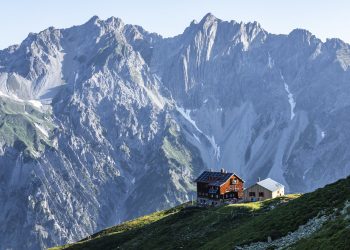
How can the term “panorama” be best defined? “Allround view; view from an elevated point in all directions, over the landscape”, according to the dictionary. Actually lying on the southeastern shoulder of the Kleinlitzner ridge, Saarbrücker Hütte (2538 m) offers the best preconditions for a magnificent panoramic view. But of course, one doesn’t have a free view “over” the mountainscape in all directions. No surprise: In respect of view, the mighty three-thousanders dominate the surrounding area, where especially the 3121 m high Große Seehorn sets the standards obstructing the view into the distance. The massive mountain on the border to Switzerland also impresses by its hanging glacier in front. Rarely does one have the possibility to come so close to such an impressive ice giant as part of a relatively easy hut tour. Saarbrücker Hütte belongs to the dying breed of mountain refuges which have still kept their hut character. In the cozy snuggery, you can enjoy various delicacies from the kitchen in a very special ambience. Due to its elevated location on the shoulder below the Kleinlitzner, Saarbrücker Hütte continuously practically pushes itself into the field of vision from the beginning of the tour. Thus, the mountain refuge itself forms a part of the panorama, which is eventually completed by the dark peaks of the Silvretta with their often green-covered mountainsides
At midsummer, alpine flowers grow along the ascent route - in many places on very barren, stony ground.
Author: Peter Freiberger -
Difficulty: mittel Technique: Condition: Experience: Landscape: Altitude: Best season: JAN FEB MAR APR MAY JUN JUL AUG SEP OCT NOV DEC Safety instructions: EMERGENCY CALL:
140 Alpine emergencies throughout Austria
144 Alpine emergencies Vorarlberg
112 Euro-emergency call (works with any cell phone/phone network)
-
Directions
A rough driveway and cart path leads from the Seespitz of the Vermuntstausee (1750 m) to Saarbrücker Hütte (2538 m). Especially at the beginning and in the last section, the trail winds up in a number of serpentines. Not least thanks to the serpentines, there are hardly any steeper sections. There are several possibilities to take a shortcut via a path in order to choose a more direct and steeper approach variation.
We take the same route for the descent. In order to protect the knee joints, it is recommended to stay exclusively along the track.
Waypoints
-
Public transportation:
Approach:
Coming on the A14, turn off near Bludenz in the direction of Montafon and drive on the B188 to Partenen where Silvretta High Alpine Road (toll route) starts. Drive to the Seespitz at the upper end of the Vermuntstausee.
Take the Montafon train to Schruns, continue by bus, suburban line 85, and get off at the stop Partenen – Saarbrücker Hütte.
Route PlannerPark:
Parking lots are available at the Obervermuntwerk and at the Seespitz.


