Hiking Trail | Hiking Trail
Warth-Schröcken | on the trail of the Walsers


-
Höhenprofil
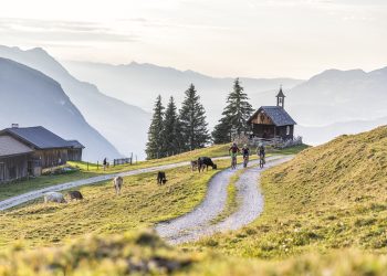
This hike follows the trail of the Walsers as far as the idyllic Körbersee and further to the Kalbelesee.
The villages of Lech, Schröcken and Warth are typical Walser settlements. In the 14th century, the Tannberg area was populated by the Walsers, who came from the West Swiss canton of Valais. In cultivating the alpine terrain, these pioneers developed a first-rate, fascinating cultivated landscape. Robust benches point out the stations along the trail. A book is available which describes the objects that tell the history of the Walser settlers on the Tannberg.
Chances to stop off for a drink/food:Hotel Körbersee, inns in Schröcken and Warth
Wanderkarte Bregenzerwald (Maßstab 1 : 32.000) Sämtliche Wanderrouten und wichtige Informationen über Bergbahnen, Hütten und Alpengasthöfe finden Sie in der Wanderkarte Bregenzerwald. Die Wanderkarte ist bei Bregenzerwald Tourismus, in den Tourismusbüros und in einzelnen Hotels erhältlich.
Presented by: Bregenzerwald
Author: Elisabeth Schneider -
Difficulty: mittel Condition: Experience: Landscape: Altitude: Best season: JAN FEB MAR APR MAY JUN JUL AUG SEP OCT NOV DEC Safety instructions:
EMERGENCY CALL:
140 Alpine emergency Austria
144 Alpine emergency Vorarlberg
112 Euro-emergency call
www.vorarlberg.travel/sicherheitstippsMore info & links: Detailed documentation in the form of a book is available from the tourist offices in lech, Schröcken and Warth. www.tannberg.info
-
Start Schröcken parish church
Coordinates:
Geogr. 47.258156 N 10.091972 EDestination Warth Waypoints
-
Public transportation:
Approach:
From Germany (Munich): A95 – Oberau – Ettal – Linderhof – Grenze Ammerwald – Plansee – Reutte – Warth – Schröcken
From Switzerland (Zurich): N3/N1 – St. Margarethen – Au – Lustenau – Dornbirn – Bödele – Bezau – Schröcken
Route PlannerPark:
Schröcken centre of town


